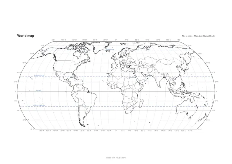
World map with latitude and longitude
A grid of degrees over the world, with the Equator and Tropics named.
Examples temporarily replace the input and settings. You can restore your previous work.
Pro keeps the settings you use every week and puts them one click away. See Pro
Free PDFs end with a small “Made with nouplo.com” line Remove limits with Pro
Save to PinterestYour files stay on your device
This tool runs entirely in your browser. Nothing is uploaded, nothing is stored, and you can even turn off your internet connection before you start.
Example
Find the city from its coordinates: a 15° world grid on one Letter sheet
A seventh-grade worksheet: students get eight cities’ latitude and longitude and mark them on the map. Settings: World, “Blank, with country borders”, lines every 15°, one sheet of US Letter. The parallels run from 60° S to 75° N and the meridians every 15° round the world, each with its degree on the edge.
- Latitude is read up or down from the Equator, longitude left or right from the prime meridian through Greenwich in London; both lines are a little heavier.
- A city between two lines lies in that box: 40.7° N is between the 30° N and 45° N parallels, a little closer to 45°.
- The Tropics of Cancer and Capricorn and the Arctic Circle are dashed and named. The map stops at 60° S, so Antarctica and the Antarctic Circle are not on it.
| City | Latitude | Longitude | Where it lies on the 15° grid |
|---|---|---|---|
| New York City | 40.7° N | 74.0° W | Between 30° N and 45° N, just east of 75° W |
| London | 51.5° N | 0.1° W | Between 45° N and 60° N, on the prime meridian |
| Quito | 0.2° S | 78.5° W | On the Equator, between 90° W and 75° W |
| Rio de Janeiro | 22.9° S | 43.2° W | Just north of the Tropic of Capricorn, between 45° W and 30° W |
| Cairo | 30.0° N | 31.2° E | On the 30° N line, just east of 30° E |
| Reykjavík | 64.1° N | 21.9° W | Just south of the Arctic Circle, between 30° W and 15° W |
| Tokyo | 35.7° N | 139.7° E | Between 30° N and 45° N, and between 135° E and 150° E |
| Sydney | 33.9° S | 151.2° E | Between 30° S and 45° S, just east of 150° E |
With 15° lines each city sits in a box 15° on a side, and students judge the rest by eye. For younger classes, “Every 30°” keeps every second line: 60° S, 30° S, the Equator, 30° N and 60° N on the sides.
How it works
- Choose every 15° or every 30° — or a continent instead of the world.
- Choose the style: borders, coastline only, or with country names.
- Press Make PDF and print; find places by their coordinates.
Frequently asked questions
- Which lines are marked?
- Every 15° or 30° of latitude and longitude, with the Equator and the prime meridian a little heavier, and the Tropics of Cancer and Capricorn and the Arctic Circle dashed and named. The world map runs from 60° S to 84° N, so Antarctica and the Antarctic Circle are left off.
- Are the degrees written on the map?
- Yes, round the edge: the latitudes on both sides, the longitudes along the bottom and the top (along the top every second one where they would crowd).
- What is it good for?
- Coordinates exercises: find a city from its latitude and longitude, or read off where a place lies.
- How do I read a coordinate like 40.7° N, 74.0° W?
- N or S is the latitude: count up or down from the Equator. E or W is the longitude: count right or left from the prime meridian (0°) through Greenwich in London. 40.7° N, 74.0° W — New York City — is a little below the 45° N line and just right of the 75° W line.
- Can I get a single continent with latitude and longitude?
- Yes: under Map choose a continent and keep the lines on. Africa with lines every 15°, for example, shows 30° N to 30° S on the sides, 30° W to 60° E along the top and bottom, and the Equator and both Tropics named.
- Is anything uploaded?
- No. The PDF is made in your browser.
Made for a specific use
- Blank map of Europe
- Blank map of Africa
- Blank map of Asia
- Blank map of North America
- Blank map of South America
- Map of Europe with capitals
- Map of Africa with capitals
- Map of South America with capitals
- Map of Asia with capitals
- Capitals map worksheet
- Large printable world map
- Blank map of Oceania
- Blank map of the Middle East
- Blank map of Central America and the Caribbean
- Map of the Middle East with capitals
- Map of Central America and the Caribbean with capitals