Continents and oceans map
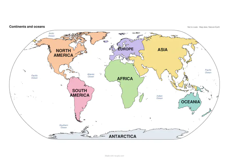
The seven continents and five oceans, ready to print.
Examples temporarily replace the input and settings. You can restore your previous work.
Pro keeps the settings you use every week and puts them one click away. See Pro
Free PDFs end with a small “Made with nouplo.com” line Remove limits with Pro
Save to PinterestYour files stay on your device
This tool runs entirely in your browser. Nothing is uploaded, nothing is stored, and you can even turn off your internet connection before you start.
Example
Continents and oceans map: 7 continents in colour, 5 oceans, and a worksheet
A Grade 3 teacher wants a coloured continents map for the wall and a quiz to go with it. The default map names the seven continents in capitals, each in its own soft colour, and the five oceans in italic — the Pacific on both sides of the map. Untick “Name the oceans” and only the land is named, under the title “The continents”.
- For the quiz, set Labels to “Numbers to fill in”: the continents become 1 to 7 (1 North America … 7 Antarctica), the oceans A to E (A Pacific, B Atlantic, C Indian, D Arctic, E Southern).
- The worksheet has Name, Date and a list to fill in; page 2 is the answer key with every name in place.
- Colours: “Shades of grey” for a black-and-white printer, or “Outline only, to colour in”. Lines of latitude and longitude every 30° add the Equator, both tropics and the polar circles, named.
- Print size 4 pages (2 × 2) makes a poster: sheets A1, A2, B1 and B2, with “Glue here” strips to join them.
| Continent | Colour | Worth knowing |
|---|---|---|
| North America | peach | Central America, the Caribbean and Greenland count here |
| South America | pink | French Guiana is coloured where it lies |
| Europe | lavender | Russia west of the Urals and the Ural river |
| Africa | light green | Egypt with Sinai, Madagascar, Réunion and Mayotte |
| Asia | yellow | Russia east of the Urals, Turkey, Cyprus, Kazakhstan, the Caucasus |
| Oceania | teal | Australia, New Zealand, Papua New Guinea, Hawaii |
| Antarctica | pale grey | drawn along the bottom of the map |
One landscape sheet — 297 × 210 mm on A4, 279 × 216 mm on US Letter — with 7 continents and 5 oceans named; the numbered version is two pages, the quiz and its answers.
How it works
- Choose the labels: names, numbers for a worksheet, or none to colour in.
- Choose seven continents or six with one America, the colours, and whether to add country borders or lines of latitude and longitude.
- Press Make PDF and print it on one page, or large over four or nine.
Frequently asked questions
- Seven continents or six?
- English-speaking schools usually teach seven, with North and South America apart; in much of Europe and Latin America America is one continent. Pick either.
- Which oceans are named?
- The Pacific, Atlantic, Indian, Arctic and Southern Oceans. Untick the oceans for a map of the land only.
- Where does Russia belong?
- Its part west of the Ural Mountains is coloured as Europe, the rest as Asia, as on most school maps.
- Is there a continents worksheet to fill in?
- Yes: set Labels to “Numbers to fill in (worksheet + answers)”. The continents are numbered 1 to 7 and the oceans lettered A to E, with Name, Date and a list to fill in, and a second page with the answers.
- Why is Turkey coloured as Asia?
- A continents map puts Turkey and Cyprus with Asia. Where two continents meet on land — the Urals, the Caucasus, Turkey's border with Greece and Bulgaria, Sinai, Panama, New Guinea — the line is drawn heavier than a country border.
- Where does the map come from?
- From Natural Earth’s public-domain country shapes, drawn as vector lines so the map prints sharp at any size.
- Is anything uploaded?
- No. The PDF is made in your browser.