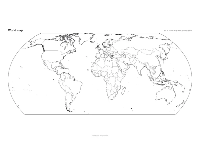
Printable blank world map
Outline maps of the world and every continent, ready to print.
Examples temporarily replace the input and settings. You can restore your previous work.
Pro keeps the settings you use every week and puts them one click away. See Pro
Free PDFs end with a small “Made with nouplo.com” line Remove limits with Pro
Save to PinterestYour files stay on your device
This tool runs entirely in your browser. Nothing is uploaded, nothing is stored, and you can even turn off your internet connection before you start.
Example
World map with country names: 35 named on one Letter sheet, 79 on nine
A teacher wants a world map with names for the classroom wall and a numbered worksheet for a quiz. Style “With country names”: a name is printed only where it fits inside its country without touching another, so the paper and the number of sheets decide how many appear.
- On 4 or 9 sheets each sheet is labelled A1, A2, B1…, with corner marks to trim and a 10 mm strip marked “Glue here” under the next sheet.
- For the quiz, “Countries numbered, to fill in” on North America prints the map with 23 numbers and lines 1 to 23 under Name and Date.
| Map | Print size | Countries named |
|---|---|---|
| World | 1 sheet, US Letter | 35 (Spain and Poland, but not France) |
| World | 1 sheet, A4 | 39 (France fits) |
| World | 1 sheet, A3 | 57 |
| World | 4 sheets, US Letter (2 × 2) | 63 |
| World | 9 sheets, US Letter (3 × 3) | 79 |
| North America, countries numbered | 1 sheet, US Letter, + answers | 23 numbers, 1 Canada to 23 Barbados |
For the wall, nine Letter sheets carry more than twice as many names as one: 79 against 35. The quiz is a two-page PDF: the worksheet, then the answers — 1 Canada, 2 United States, 3 Mexico, 4 Guatemala and so on to 23 Barbados.
How it works
- Choose the world or a continent.
- Pick a style: blank with borders for a geography quiz, coastline only for drawing, or with country names in your language.
- To colour countries, press Zoom & colour above the preview, pick a colour and tap the countries on the large map; they go into the colour lists of the form.
- Choose the paper and press Make PDF — the lines are vector, so they print sharp at any size.
Frequently asked questions
- What can I use a blank map for?
- Geography lessons and quizzes (“name the countries”), colouring by language, climate or travel, planning a trip, or marking where family and friends live.
- Why are some countries not named?
- Names go only where they fit without overlapping, so very small countries — in Europe, the Caribbean or the Pacific — are left blank on A4. Print on A3 and more of them get a name. On a continent’s map every independent country is named, a small one beside it on a thin leader line.
- Which languages are the names in?
- In the language of this page. The names come from the standard country names of the Unicode locale data.
- Where does the map come from?
- From Natural Earth, a free public-domain map dataset, drawn with a world projection that keeps the continents’ shapes and sizes in balance. The maps are not to scale: don’t use them to measure distances.
- Is there a blank map with numbers to fill in?
- Yes: choose “Countries numbered, to fill in (worksheet + answers)”. Each country gets a number on the map, the sheet has a numbered line for each, and a second page lists the answers. North America has 23, from 1 Canada to 23 Barbados; South America 12, from 1 Ecuador to 12 Brazil.
- Can I print a large world map for a wall?
- Yes: under Print size choose 4, 6 or 9 pages. Each sheet is labelled (A1, A2, B1…), has corner marks to trim and a 10 mm strip to glue under the next one. With names on, more countries fit as the map grows: 35 on one US Letter sheet, 63 on four and 79 on nine.
- Can I colour the map by clicking?
- Yes. Press Zoom & colour above the preview: the map opens full screen, where you zoom with the wheel or two fingers and drag to move it. Pick one of six colours (each can be changed) and tap countries to paint them; tap a country again with the same colour to clear it. Tiny countries get a circle to tap. The countries you paint are written into the colour lists of the form, so the preview, the PDF, PNG and SVG and the legend all follow.
- Is anything uploaded?
- No. The PDF is made in your browser.
Made for a specific use
- Blank map of Europe
- Blank map of Africa
- Blank map of Asia
- Blank map of North America
- Blank map of South America
- Map of Europe with capitals
- Map of Africa with capitals
- Map of South America with capitals
- Map of Asia with capitals
- Capitals map worksheet
- World map with latitude and longitude
- Large printable world map
- Blank map of Oceania
- Blank map of the Middle East
- Blank map of Central America and the Caribbean
- Map of the Middle East with capitals
- Map of Central America and the Caribbean with capitals